Again it is up at 6am for me, though we need to be away today by 7am for our journey to Mount Giluwe. There is a bit of a drive to get to our start point. I feel fine after yesterday’s exertions on Mt Hagen. Hopefully the fact that I reached about 3,600m (11,800ft) will have helped with the acclimatisation.
I breakfast outside on the deck next to the dining area. It is rather pleasant.

We leave promptly. Arrangements for this trip have been made by Paiya Tours who run the Magic Mountain Nature Lodge. Paiya Tours is owned by Pym and Elisabeth Mamindi. Other than the disappointment on Mt Hagen I found the arrangements they put in place to be excellent. An advantage of organising a bespoke trip is that I could dictate the arrangements. This I did for Mount Giluwe by adding an extra day in case of bad weather (or the climb being more difficult than I expected). So I had the option of doing the climb in two or three days. The decision would be made once I was on the mountain.
Mount Giluwe is a shield volcano. Standing at 4,367m (14,327ft) it is the second highest peak in Papua New Guinea and the highest volcano in Australasia. Shield volcanoes compare to stratovolcanoes in that the latter form cones with a distinctive crater or craters in the middle rather like Pico de Orizaba in Mexico (see my November 2014 blogs), Mount Damavand (see my October/November 2015 blogs) or the classically shaped Mt Fuji in Japan.
Shield volcanoes on the other hand are “a type of volcano usually built almost entirely of fluid magma flows. They are named for their large size and low profile, resembling a warrior’s shield lying on the ground. This is caused by the highly fluid lava they erupt, which travels farther than lava erupted from stratovolcanoes. This results in the steady accumulation of broad sheets of lava, building up the shield volcano’s distinctive form. Shield volcanoes shape is due to the low-viscosity magma of their mafic lava”. (thanks to Wikipedia for that explanation)
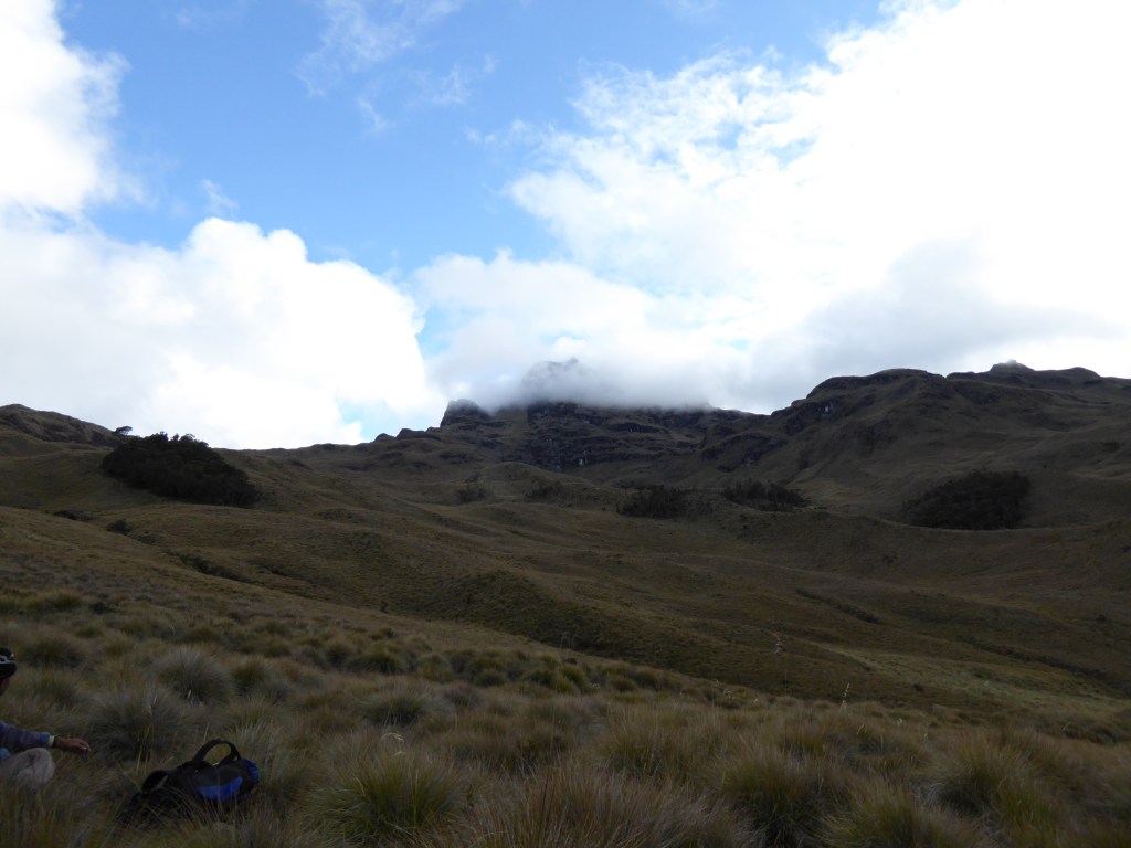
So my first view of Mount Giluwe which was from around 16 miles (26 km) to the north east bore this out.

And here is a zoom from the same spot.

Such volcanoes tend to be low and flattish. But there are exceptions, including Mount Giluwe and the Hawaiian volcanoes. What they all have in common is that they each individually cover large areas of the Earth’s surface (because their lava flows are so much more viscous). Mount Giluwe is about 15.6 miles (25km) north to south and 12.5 miles (20km) east to west (that’s about 180 square miles).
Now for the final bit of geology. Mount Giluwe in its current state formed around 220,000 – 300,000 years ago. In fact it sits on top of an even older stratovolcano which is significantly eroded but remnants of its volcanic plugs form the mountain’s various summits.
As usual I am travelling in a Land Cruiser. The driver and one other accompany me. We follow the Highlands Highway for a short while before turning left off it. Here the road deteriorates, although still metalled. At one point almost half the road has subsided down the hillside. I wouldn’t have like being driven there in the dark! A bit further on some locals sit by the side of the road selling their wares. We stop. Food and some clothes are on offer. My driver buys some peanuts which we share between us.
We grind in low gears over some high ground (from where the Giluwe pictures above were taken) and then lose height again. Eventually we reach the town of Tambul where the tarmac runs out. In fact I would go so far as to say that once on the other side of Tambul the road runs out to all intents and purposes.
Now I have been on rough roads in my time in Namibia, in Egypt and in the Northern Territory of Australia. But this one beats them all. We end up driving over and along boulders. It is like being tossed around on a boat in a violent storm. I have to hold on hard to stop my head banging on to the sides or even the roof of the vehicle.
Eventually we stop. Here is the entrance to part of the village of Mailka. This will be my starting point.

I get out of the car with my companions and by the time I have also pulled out my rucksack I am surrounded by a couple of women, a few more children and some excited noise. I am led up the muddy path and this opens up to a level grassy clearing in which there are two huts. Gedion and his brother are waiting for me there. There is some discussion with a couple of boys over where some pots and pans are to be stuffed.
My driver and companion have some food which is distributed, and a tent. In my discussions back at the Lodge I say that a tent is not necessary. I am not entirely certain where I will stay the night. Caves have been mentioned. If caves are to be involved, that is where I want to stay. But the group insist that we take the tent. It soon becomes apparent that the boys (Yarex and Rendy) are to come along. They are 12 and 10 years old, I think.
So I am to be accompanied by Gedion, his brother and the two boys who I ascertain to be Gedion’s sons. As the final bits and pieces are being assembled it is suggested that the boys lead me off. They have shoulder bags and one carries a kettle in his hand. So at around 8.30am we leave the village.
Immediately behind the village we weave our way around a considerable area of these mounds. Here are where the village’s staple, the sweet potato, is grown.

Beyond, there is an area of maintained grassland. This is not grassland for grazing animals. Here the long grasses are cut as material for bedding, thatching and the like. Next we move into an intermediate area where the jungle begins with a mix of grass, stunted trees and larger trees.
The path is clear but sometimes consists of deep runnels where tropical rains have carved deep cuttings. Sometimes we walk along their sides, sometimes along the bottom. Soon we are in the jungle. Here is the path near the start.

The previous day’s outing on Mount Hagen has prepared me for the nature of the terrain. My guides move through it effortlessly. Gedion is wearing green wellies with holes in them. The others walk in bare feet. Conversation is sparse, in part because only Gedion has any sort of confidence with English. To start, the way is not so much of an obstacle course. Perhaps the villagers keep it clear near the village. The climbing is steady. There are a few branches in the path, thank goodness I have guides! Otherwise I would soon be lost. On occasions at a steepening in the path there is a staircase of tree roots.
It is difficult to gauge what progress is being made. It is warm and muggy. Looking straight up the blue sky is broken by large puffy white clouds. The sun dapples the ground. There is the occasional small clearing where a larger patch of sunlight finds the ground. But generally the jungle is quite oppressive as we weave our way ever on. After an hour and a half we descend a little to where a stream cuts its way through the jungle. We stop for a break. Although I understand from my research that the water is safe to drink in the jungles of PNG I decide to rely on the bottled water I have brought from the Lodge for the time being. Now is not the time to risk a tummy bug.
We set off again. At one point we pass a stick thrust vertically into the ground. It is charred and has a pointed end to it. I enquire as to its presence and they tell me that the locals have caught and then cooked a cuscus here. A cuscus is a type of marsupial the size of a domesticated cat. It is slow moving and nocturnal. So easy to catch perhaps, assuming you can find it in the first place.
Another hour later and the jungle shows no sign of ending. We have another brief stop. I pull a snack out of my rucksack. The elder of the two boys pulls out a catapult. He starts firing small rocks at nearby trees.
I decide that an English lesson is now in order. I ask him if he knows what he is holding is in English. Of course, the answer is “no”. So I say “catapult”; he tries to copy me: “cuttle”. Mmm. I try a different tactic. Cat – a – pult. Cat – a – pult (even more slowly this time). I ask him if he knows what a cat is and go “meow”. A grin appears on his face. Yes he knows what “cat” is. The others watch and listen intently, dad amused. So I say “cat – meow – a – pult” a few times. “Cat – a – pull” is the response. Ah ha, perhaps I am getting somewhere.
I have him repeat it a couple of times. Let’s see if it sticks. Meanwhile the two adults are having their third or fourth cigarette of the trip. Occasionally I would be toiling upwards and one or other would disappear to light up. They would still catch me up though soon enough!
The lesson over, it is time to move on. Off we go. Eventually, three hours after setting off we emerge from the jungle and into the open grassland above.

We carry on for 5 minutes and we stop for lunch. I have some cheese sandwiches, juice and fruit supplemented by a snack that I have brought. Here is a view back to the upper edge of the jungle.

We stop for 40 minutes. I start off again leaving the adults puffing away on yet more cigarettes. The boys show me the way. There is a faint trail in the grass. The ground climbs a little more steeply now. The three of us are some way ahead of the adults now. I take a couple of shots back to them at varying level of zoom.


A little further on there are some caves. Unfortunately these are not the ones that we are to stay in. But from near the caves, looming in the cloud, I can see the first evidence of volcanic remnants.

This shot is another zoom. Here is the view without the zoom.

The trail trends up to the ridge on the left of the photo and skirts the little plug in the top left of the photo. In fact most of the way today there is a trail, sketchy in places. It takes about 50 minutes to walk from here to beneath the outcrops in the distance. Just as the ridge merges into the higher ground, the path veers off and to the left. A short section of undulating ground where another ridge joins is followed. A descent into boggier ground then follows.

But the landscape starts to become a little more interesting. Trending to the right a short valley is entered with volcanic plugs rearing above.

Here is a view back along that valley.

The ground now rises more steeply up on to a plateau.

For a while the ground is quite wet and rough before it opens up on the final rise. The ascent here will be around 200m (660ft).

As the plateau is reached we are surrounded by outcrops. It is now over 2½ hours since we stopped for lunch. We arrive at the northern edge of the plateau. The summit is nearer the southern edge.

There is then a short ridge with an annoying steep and deep down and up before we reach the main part of the plateau. Clouds sweep over us from time to time. There is a little drizzle in the air but nothing too wetting.


Finally we are on the plateau. The plateau is wet. A few tarns are dotted about. As we cross, the majority of steps are accompanied by a splash or a squelch. But rarely is the water more than a few centimetres deep. Ahead there is a blanket of cloud that prevents much of a view. But 40 minutes later a brief break in the cloud allows me to take this shot of Mount Giluwe’s twin summits. We have been going almost 7 hours.

A few moments later I am able to take these dramatic zoomed shots of each summit.


Half an hour later this is what the view to the main summit looks like.

The team decide they want me to take their photo (note the bare feet and wellies). We have a brief stop for drink and a snack.

Although the summit (which is behind them in the cloud) does not look that far away, it is another 1 hour 45 minutes before we arrive at this point. This sight comes into view shortly after the start of a rather disconcerting 300m (1,000ft) drop into a valley separating us from the main peak. Tucked in out of sight on the slope below is a piece of woodland where I am told there is a hut.
By now, 9 hours after we have started out, I am becoming decidedly weary. We work our way down some steep grassy slopes and then cross a more level wet section before continuing our downward path. The woodland comes into view and Gedion goes ahead to check the hut. He comes back and says we will not be staying there – it has burnt down, or perhaps has been burnt down.
A brief explanation might be in order here. Gedion has explained to me that Mount Giluwe is on his tribe’s land. He has repeated this on a number of occasions. I know that ascents are made also from the other side of the mountain through other tribal lands. Gedion acknowledged this. There is therefore the possibility that someone from another tribe has been up here and has set the hut alight. He and his brother scan the valley and Gedion announces that there is another hut in a piece of woodland on the other side of the valley.
I look at where they were pointing. I can certainly see the woodland, but I can see no sign of any hut. So we traipse off across trackless tussocky grassland down to a large stream, hop across on some rocks and start climbing up similar terrain towards the woodland. Here is the view of the woodland. See the hut?

No, neither can I.
Well here it is.

We arrive at the hut 9¾ hours after we leave the village. The kids are sent down to the river to collect water in the pans that they have been carrying. They are then given a machete so as to cut some of the dry grass. In the meantime Gedion and his brother start wielding the axe to chop wood for the fire. I try to make myself useful by collecting smaller, fallen branches.
The hut needs some upgrading. A wall at the rear of the hut needs to be installed. This is to ensure that the air movement goes up to the gap in the roof rather than through the hut. So some significant branches are felled to do this. Within the hut there is a raised sleeping platform on one side of the hut, a fire in the middle and on the other side, and slightly below the fire, another area about a metre wide against the sloping boughs of the other long wall.
The grasses collected by the boys are placed on the sleeping platform and in the metre wide area. It is also used to stuff the gaps in the newly formed wall at the far end. Some spare grass will be used as kindling for the fire.


The chopping goes on for quite some while. I am offered the tent, but I decline. I haven’t come this far not to sleep in the hut! Gradually the wood for the fire grows to enormous proportions and the adults light it. It is soon raging. The smoke largely vents up through the slit in the roof though the atmosphere within the hut becomes a little smoky.
Gedion starts to prepare a meal. Yarex, who has been carrying a few sweet potatoes places them adjacent to the fire. Over the next couple of hours he turns them on a regular basis as they roast. Gedion concocts a mush out of corned beef and rice. This is preceded by soup made out of packets. Hot water accompanies. I am surprisingly dehydrated notwithstanding the humidity. So whilst I drink I do not feel all that hungry. I decline seconds and the rice pudding that was available for desert.

I take a sweet potato when it is offered but choose the smallest. It is a struggle to eat it and I need to wash each mouthful down.
Gedion, his brother and Rendy will sleep up on the platform. Being slightly higher than the fire that might keep them warm. They have brought no blankets (or anything to cover them). Yarex and I will occupy the small area on the other side of the fire. I have brought a light down sleeping bag with me.
At one point I go out of the hut to relieve myself. It is decidedly chilly out there. We are probably 800m to 1,000m below the summit – so at around 3,400m (11,200ft). Above the sky is clear and without any light pollution I can see zillions of stars. To the north, though, I see regular flashes of lightning. Let’s hope that that weather does not move our way.
Back in the hut we are ready to settle down. The boys are cold – so I lend them each a spare pair of socks that I am carrying. I also lend Yarex some gloves. Gedion’s brother also borrows some gloves. My guilt at being in the comfort of a sleeping bag is therefore somewhat assuaged.
I fall asleep with the warm glow of the fire heating my face looking forward to what the morning will bring.
Here is a link to Part 4, completing the ascent of Mount Giluwe.
Leave a Reply