La Plata means “silver” in Spanish. This reflects the mining history in this part of Colorado. In a future posting I will provide some photos of the “ghost” mining town of Winfield.
La Plata Peak is one of Colorado’s 14’ers (standing at 14,336ft), in other words one of the 53 listed 14,000ft mountains. Two days previously I had climbed Mount Massive. I had given myself the following day off to recuperate and to see if my body would suffer any adverse reaction to going to over 14,400ft so soon after arriving in Colorado.
Fortunately there was no adverse reaction and I was good to tackle Colorado’s 5th highest peak. The evening before I recced the start as the route finding is a little complicated. However, this particular trailhead is one of the few in Colorado that starts at a paved road. The trailhead is at 10,000ft and I was taking the North West Ridge route which involves ascent of around 4,500ft to the summit and a round trip of about 9½ miles.

The trail (which starts as a 4 wheel drive road) first descends to cross a river over a wooden bridge. Signs nearby warn not to take water from the river because of pollution from 19th century mines. After 500 further yards it then leaves the road to pass through a bit of woodland and reaches a rocky linn through which a further river rages. Passage there is over a new wooden footbridge.


This is where I stopped that evening.
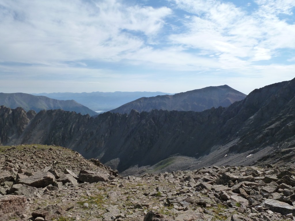
This is a view of what I would be tackling the following day – the peak on the left with the large patch of snow.

The following morning I left the trailhead at 7am. There was only one car plus a minivan with trailer there before me. I retraced my steps to the footbridge over the linn. The trail then weaved its way for almost a mile through more forest to a narrower stream where crossing was via some dodgy branches.

I was now in La Plata Gulch, the approach valley. The trail then starts some serious climbing. In places, the trail has been improved.

There is an organisation called the Colorado Fourteeners’ Initiative that raises funds for improvement for access. This includes trail improvements and negotiations with private landowners for access. There is no equivalent position to that in Scotland (or Access Land in England) where there is a right to roam. Access is generally available on public land, often subject to conditions, but access over private land has to be negotiated unless there is a subsisting right of way.
The weather was not as good as it had been two days earlier. High thin cloud covered the sky, but that would take away some of the heat later on. After a 1,000ft or so of ascent through the forest near to a tumbling river, the terrain levelled out at meadows in the upper valley.

The trail then leaves the valley to the left (east) and makes a rising traverse for around 400ft. It then made a sharp left turn up a shallow gulley on the flank of La Plata’s north west ridge and went steeply up in innumerable switchbacks for another 300ft.

The final trees were left behind and a more gentle traverse along the side of the ridge started, including a ¼ mile stretch across talus (where the path was still clear). Views started to open up. Here is one back to Casco Peak which misses the 14,000ft contour by just 92ft. Mount Elbert (Colorado’s highest) is the pointy one to the right.

The traverse took me to a small level area at around 12,300ft where I passed a couple of guys descending. They were not interested in passing the time of day, but I stopped to drink and eat. I managed my fluid and food consumption much better than I had done on Mount Massive.
It was just another 400 to 500ft up to the crest of the north west ridge and this was achieved in short order. It is at this point that the crowning glory of La Plata comes into view. Now most of the giants of the Sawatch Range in the Colorado Rockies are a bit like overgrown Cairngorm Munros – perhaps the rock is a bit looser and the boulder fields are bigger, but generally there is little technical difficulty that cannot be avoided. But across to the east La Plata supports the Ellingwood Ridge which is a 2 mile long sawtooth ridge. The start point for this is the same as where I had started but the 1,400ft is added to the total ascent with all of the ups and downs. Voila!

You will see another view of the ridge from higher up in a moment. The next shot is one up the ridge. The summit is the point behind and to the left. From here it is still 1¼ miles away with 1,600ft of ascent broken by a short level section.

The path you can see in the photo soon disappears and the terrain becomes predominantly a series of boulder fields. Cairns show the ways through and scrambling is often necessary to surmount or make your way around some of the blocks. On the first part of the climb I went around to the right of the first rise but it would have been easier to stick to the ridge line (as I found out on the way down). Now here is a view up the second rise beyond the short level section. You can get a better feel for what was under foot. It wasn’t difficult but you had to be slow and methodical in places.

Soon after I passed a group of 8 kids and 3 teachers – from the minivan I had seen at the trailhead. They had been camping in the valley I had passed through – very inconspicuously as I had not seen their tents!
Before the final rise I sat down for more food and drink. Just 750ft of ascent and ½ mile to go now. Elllingwood Ridge was now below me.
Having had my rest, I continued on finding an intermittent trail and continuation of cairns. Near the top the ground could be a little confusing in mist. Two tops can be seen rising ahead. The correct one is the one to the left which is nearer. The other is just a bump on the south west ridge which is another popular approach of similar character to the one I had used (but a bit shorter). There was just a final 150ft climb up to the rough summit ridge.
Here is a view down from shortly before that final climb to my route of ascent. I can assure you that the shot is a little misleading due to the foreshortening of that view.

You can see the road where the trail head is. This is called the Independence Pass road and leads over to the ski resort of Aspen off to the left (west). The approach valley is clear and the switchbacks I mentioned are just beyond the nearest block of trees that rise up the side of the ridge on the right.
I had the summit to myself, or at least I thought I did…..
Anyway, first of all some views from the top. I had reached the top in just over 3½ hours from the start.


Well two things happened. First a group of four local guys from Leadville turned up. They were surprised to find someone with a strange accent on this mountain. I had heard them coming for a while. They had gone off to bag a subsidiary summit and they were walking over some very loose ground. So I could hear the loose rocks being knocked about.
Secondly, most of the time I had been on top I could hear this irritated squeaking. As the group of four arrived this became more intense. We found this rather upset marmot.

We were clearly encroaching upon its territory. There appeared to be an entrance to a burrow just below its butt (sorry just using the American term!) Here is a close up.

Nature had its way of ensuring that us being a cause of its irritation was as short as possible. The cloud had been building up. As I had mentioned in my blog for Mount Massive, it is common for thunderstorms to build up in the early afternoon. Shortly after I has taken this picture:

A big flash followed within no more than 2 seconds by the loudest clap of thunder I had ever heard occurred. I could feel the pressure waves from the thunder. We needed no further invitation to flee the summit. I had been at the top for almost 45 minutes in any case. I am sure the marmot was pleased at the turn of events!
For the next 40 minutes or so as we descended the regular rumble of thunder accompanied us. About 800ft lower we met several groups who were wondering about turning back. It was only 11.45am and a bit early for normal thunderstorm activity. A few did and a few didn’t. As it happens the atmospheric activity died down though it did start to rain. This was great because it was refreshing and cleared the air.
One aspect of the Colorado Rockies was the amount of flora and fauna. I will post some photos of the former in my next blog (see also the Mount Massive blog). Not only were there marmots but also ground squirrels, chipmunks and pikas.

They tended to live amongst the rocks and a chorus of warning sounds would arise as I walked amongst them. The chipmunks were too difficult to capture on camera because they moved too fast!
I met more people going up when I reached the valley bottom, including a group of three girls wearing short sleeve tops, cropped trousers and trainers. In Colorado the norm is to wear trail shoes rather than the leather boots I was wearing. So in US terms, trainers were not wholly out of the way. But the remainder of the attire left something to be desired.
I was back at the car by 1.40pm – a 6 hour 40 minute round trip. A zoom back to La Plata at the end on which you can see the top end of the Ellingwood Ridge, the false bump on the south west ridge on the right, the two rises in the ridge and the low point in the ridge where the trail joins below which is the short level section.

A better management of, particularly, fluid intake meant that I had no difficulty with the altitude – no hint of the nascent headache or slight nausea I had had on Mount Massive two days earlier. On to the next climb!
Leave a Reply